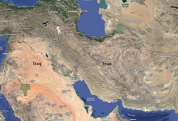
When analysts talk about Iran, they too often reduce it to politics, nukes, or ideology. But any real understanding of the strategic challenge must begin with geography. Iran is not Iraq; it is not Afghanistan. It is a vast land mass defined by mountain ranges that have shaped its history, defense, and resistance to outside powers for millennia.
Iran covers roughly 1.65 million square kilometers, making it more than three times the size of Iraq and significantly larger than Afghanistan. Its internal geography isn’t open plains, but a series of rugged, interconnected mountain systems with high interior basins and plateaus wedged between them. The two dominant ranges, the Zagros in the west and the Alborz in the north, surround the country’s heartland, rise above 3,000 meters, and in places top 4,000 meters, creating what military theorists have called a mountain fortress